- 3:55 h
- 11.19 km
- 561 m
- 671 m
- 1,598 m
- 1,953 m
- 355 m
- Start: Bannalp (Oberrickenbach)
- Destination: Ristis (Engelberg)
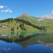
At the beginning and end of this panoramic hike we take the cable car to Bannalp or from Ristis down to Engelberg. But not all differences in altitude have been overcome yet: 561 metres of ascent and 671 metres of descent have to be mastered on the well-secured mountain path - a unique alpine experience for (almost) everyone.

Good to know
Best to visit
suitable
Depends on weather
Directions
From the Bannalp mountain station, the hike starts with the ascent to Walenegg - the highest viewpoint of the Walenpfad. Towards the end of the tour, tired hikers can enjoy an "Älperzneyni" (traditional snack) at the Brunnihütte. On the "Kitzelpfad" around the "Härzlisee" (small lake), you wade on moor, gravel, wood chips and stones and enjoy the tingling feeling of natural relaxation. This is followed by a short descent to Ristis (chairlift as an alternative). The cable car brings us to Engelberg.
Tour information
Nature Highlight
Equipment
Eine gute Ausrüstung inkl. Regen- und Wärmeschutz ist empfohlen.
Additional information
More information:
Nidwalden Tourismus
Bahnhofplatz 2
6370 Stans
+41 (0)41 610 88 33
info@nidwalden.com
www.nidwalden.com
Nidwalden Tourismus
Bahnhofplatz 2
6370 Stans
+41 (0)41 610 88 33
info@nidwalden.com
www.nidwalden.com
More hiking trails: nidwalden.com/hiking
Author
Nidwalden Tourismus
Organization
Nidwalden Tourismus
Author´s Tip / Recommendation of the author
Tip: Buy the round trip ticket with all cable cars included! www.zentralbahn.ch
Nearby