How would you like to arrive?
- 8:00 h
- 19.57 km
- 1,360 m
- 1,360 m
- 435 m
- 1,807 m
- 1,372 m
- Start: Stans, train station
This route links Nidwalden's political, historical, spiritual, geographical and topographical centers. Local history is the central theme.
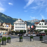
The starting point for this hike is Stans, the capital and political center of Nidwalden - more specifically, above the town square in Wil on the Aa River. This is the historic place where the people of Nidwalden used to meet every year to vote. The route continues along the Engelberg portion of the Aa toward the canton's geographical center. But first you'll pass through quiet Niederrickenbach, the canton's spiritual center and a place of natural beauty. From there the path leads up to the Buochserhorn. Its summit is the topographical center of Nidwalden. From up there you can enjoy a magnificent panoramic view of Lake Lucerne as well as all 11 municipalities of Canton Nidwalden. The end point of the hike is Buochs, the geographical center of the six central Swiss cantons of Lucerne, Zug, Schwyz, Uri, Obwalden and Nidwalden.
Note(s)
Accommodations available in Niederrickbach.
Follow the logo pictured (Route 570) on the yellow signposts.
See also
For Supported Areas
GEO-Tracks GmbH
Zugerstrasse 1
CH-6330 Cham
Web: www.gps-tracks.com
E-Mail: touren@gps-tracks.com
Waypoints
Good to know
Best to visit
Directions
Organization
Nidwalden Tourismus
Nearby


